Gaudiya Vaishnava pilgrimage places: an atlas with map and sources
Where are the places that Gaudiya Vaishnava pilgrims travel to, and why do they matter? This atlas lists 34 of them, from the temple town of Puri on the Bay of Bengal to the villages of Vraja around Mathura, with the reason each one is remembered, its location, and links to official sites and reference works.
The selection follows the geography of the tradition itself: the places of Chaitanya's life in Bengal and Orissa, the stops on his journeys that his biographers recorded, the homes of his companions, and the sites of Vraja that the Gosvamis of Vrindavan described and restored. Coordinates, districts and states come from Wikidata, extracted on 13 November 2026. The descriptions are our own.
Map
Find a place
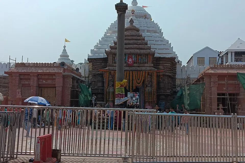
Jagannath Temple, Puri
Twelfth-century temple of Jagannath, Balabhadra and Subhadra. Chaitanya made Puri his home from 1510 until his death in 1534, and the temple stands at the centre of Gaudiya devotion to Jagannath. Entry to the temple is restricted to Hindus. Our article.
OpenStreetMap · Wikipedia · Wikidata Q1678260 · Shree Jagannatha Temple Administration
Gundicha Temple, Puri
Garden temple about 3 km from the main temple, at the other end of the Grand Road. The three chariots of the Ratha-yatra bring the deities here for a week. The Chaitanya-charitamrita describes Chaitanya and his companions washing the temple before the festival. Our article.
Alarnatha Temple, Brahmagiri
Vishnu temple at Brahmagiri, about 25 km west of Puri. During the fortnight after the bathing festival, when Jagannath is withdrawn from view in Puri, pilgrims go to Alarnatha instead, as Chaitanya is said to have done.
Sakhigopal Temple
Krishna temple between Puri and Bhubaneswar. Its image, Sakshi-gopala ("Gopala the witness"), is the subject of a story told in the Chaitanya-charitamrita about a deity who walked from Vrindavan to testify to a promise.
Remuna
Town near Balasore, home of the Kshira-chora Gopinatha temple. The name, "Gopinatha who stole the sweet rice", comes from a story about Madhavendra Puri, Chaitanya's grand-teacher, retold in the Chaitanya-charitamrita.
Simhachalam Temple
Hilltop temple of Varaha-Narasimha above Visakhapatnam. Chaitanya visited it on his tour of South India in 1510–1512, according to the Chaitanya-charitamrita.
OpenStreetMap · Wikipedia · Wikidata Q2620389 · Simhachalam Devasthanam
Mayapur
Village on the east bank of the Ganges, opposite Nabadwip. Bhaktivinoda Thakura identified it in the 1880s and 1890s as Chaitanya's birthplace; many Gaudiya institutions now have their headquarters here. The identification is not accepted by all, see Nabadwip. Our article.
Nabadwip
Old centre of Sanskrit learning where Chaitanya was born in 1486 and taught as a young scholar. Many temples in the town keep a rival tradition that places the birthplace on the west bank, within Nabadwip itself. Its Ras festival in autumn draws large crowds. Our article.
OpenStreetMap · Wikipedia · Wikidata Q1006330 · Nabadwip Municipality
Santipur
Home of Advaita Acharya, the senior associate who, in the tradition's account, called for Chaitanya's appearance. The town is also known for its handloom saris and its Ras festival.
Kalna
River town associated with Gauridasa Pandita, a companion of Chaitanya and Nityananda. It is also known for the terracotta temples built by the Bardhaman rajas.
Panihati
Ganges-side town north of Kolkata. Its annual Danda-mahotsava, the "chida-dahi" festival of flattened rice and yoghurt, recalls Raghunatha dasa's meeting with Nityananda there.
OpenStreetMap · Wikipedia · Wikidata Q1801463 · Panihati Municipality
Ekachakra
Village in Birbhum district held to be the birthplace of Nityananda, Chaitanya's closest companion in the tradition's narratives.
Katwa
Town on the Ganges where Chaitanya took the vows of a renunciant (sannyasa) from Keshava Bharati in 1510, before leaving Bengal for Puri. Our article.
Srikhanda
Village near Katwa, seat of Narahari Sarakara and of the Srikhanda family of Vaishnava physicians and poets.
Ramkeli
Village near the ruins of Gaur in Malda district where Chaitanya met the brothers Rupa and Sanatana, then ministers of the Bengal sultan, in 1514. A fair is held there every year; the Madanmohan temple marks the site. Our article.
Vrindavan
Town on the Yamuna, the centre of Krishna worship in Vraja. The Six Gosvamis settled here in the sixteenth century at Chaitanya's request and founded its first great temples. Our article.
Mathura
City regarded in Hindu tradition as the birthplace of Krishna, and the usual starting point of the Vraja-mandala circuit. Our article.
OpenStreetMap · Wikipedia · Wikidata Q200311 · Mathura district administration
Govardhan Hill
Low sandstone ridge west of Mathura that, in the Bhagavata Purana, Krishna lifts to shelter the cowherds. Pilgrims walk the circuit round it, about 21 km, often barefoot. Our article.
Radha Kund
Sacred pond and small town at the north end of Govardhan. The Chaitanya-charitamrita credits Chaitanya with locating the pond during his visit to Vraja; Raghunatha dasa Gosvami lived on its bank for decades. Our article.
Kusum Sarovar
Stepped tank on the Govardhan circuit, framed by an eighteenth-century sandstone memorial built by Jawahar Singh of Bharatpur for his father Suraj Mal.
Barsana
Hill village honoured as the home of Radha, with the Ladli-ji temple on its summit. Known for its Lathmar Holi, played with the men of Nandgaon.
Nandgaon
Village of Nanda, Krishna's foster father, crowned by the Nanda Bhavan temple. Its men take part in the Lathmar Holi of Barsana.
Gokul
Village across the Yamuna from Mathura where, in the tradition, the infant Krishna was raised by Nanda and Yashoda.
Kaman (Kamyavan)
Town in Rajasthan identified with Kamyavan, one of the twelve forests of Vraja visited on the full Vraja-mandala circuit. Our article.
Madan Mohan Temple, Vrindavan
Sandstone temple on a hill above the Yamuna, linked to Sanatana Gosvami and among the oldest standing temples of Vrindavan. Its original image was taken to Rajasthan in the seventeenth century and is now worshipped at Karauli. Our article.
Govind Dev Temple, Vrindavan
Monumental red sandstone temple completed in 1590 under Raja Man Singh of Amber for the image of Govinda served by Rupa Gosvami. The image was later moved to Jaipur, and the temple's upper storeys are lost. Our article.
Radha Damodar Temple, Vrindavan
Temple associated with Jiva Gosvami. Its courtyard holds the memorial tombs (samadhis) of Rupa and Jiva Gosvami. Our article.
Radha Raman Temple, Vrindavan
Temple of the image associated with Gopala Bhatta Gosvami, which temple tradition dates to 1542; the present building is from the nineteenth century. Our article.
Govind Dev Ji Temple, Jaipur
Temple in the City Palace complex of Jaipur that houses the Govinda image brought from Vrindavan in the early eighteenth century. It is one of the busiest Krishna temples in Rajasthan.
Prayagraj (Prayag)
City at the confluence of the Ganges and Yamuna where, according to the Chaitanya-charitamrita, Chaitanya instructed Rupa Gosvami in the principles of devotion for ten days. Our article.
OpenStreetMap · Wikipedia · Wikidata Q162442 · Prayagraj district administration
Varanasi
City where Chaitanya taught Sanatana Gosvami for two months and, in the tradition's account, won over the Advaita Vedanta teacher Prakashananda Sarasvati. Our article.
OpenStreetMap · Wikipedia · Wikidata Q79980 · Varanasi district administration
Vishnupad Temple, Gaya
Temple built over a footprint attributed to Vishnu. Here in 1508 the young scholar Nimai, later Chaitanya, met Ishvara Puri and received initiation, the turning point of his life in every biography. Our article.
Ranganathaswamy Temple, Srirangam
Vast temple of Vishnu as Ranganatha on an island in the Kaveri. Chaitanya spent the four months of the rainy season of 1511 here with the family of Venkata Bhatta, father of Gopala Bhatta Gosvami.
Udupi Sri Krishna Matha
Krishna temple founded by the thirteenth-century philosopher Madhvacharya, visited by Chaitanya on his southern tour. Gaudiya lineages trace their succession through Madhva's order, a link that historians debate.
OpenStreetMap · Wikipedia · Wikidata Q2044395 · Udupi Sri Krishna Matha
Before you travel
Practical rules change, and the bodies that run temples and festivals publish them. Check the temple administration or the state tourism department before a visit:
- Shree Jagannatha Temple Administration, Puri: temple timings, rules of entry and the festival calendar. Non-Hindus are not admitted to the Jagannath temple.
- Odisha Tourism: Puri, Sakhigopal, Remuna and the Ratha-yatra.
- West Bengal Tourism: Nabadwip, Mayapur and the Nadia towns.
- Uttar Pradesh Tourism: Mathura, Vrindavan, Govardhan and Barsana.
- Rajasthan Tourism: Jaipur and the Rajasthani part of Vraja.
Festival dates follow the Hindu lunisolar calendar and move each year against the Western calendar; the Ratha-yatra falls on the second day of the bright half of Ashadha (June or July). Our articles on the Ratha-yatra and on the Vraja-mandala circuit give more detail.
Method, sources and licence
Selection. 34 places chosen by us because the tradition's own histories, above all Krishnadasa Kaviraja's Chaitanya-charitamrita (c. 1600), tie them to Chaitanya, his companions or the Gosvamis, or because they belong to the Vraja pilgrimage circuit. The list is not exhaustive: Vraja alone counts hundreds of sacred groves, ponds and shrines. Temples associated with other Krishna traditions, such as those of the Haridasi or Vallabha lineages, are left out unless Gaudiya history passes through them.
Data. For each place, the coordinates (property P625), the administrative chain (P131, walked up to the district and the state), the official website (P856) and the English and French Wikipedia articles were read from Wikidata through its public API on 13 November 2026. Coordinates are rounded to four decimals (about 10 m) and give the item's reference point, not an entrance.
Corrections. Two items had no district in their Wikidata administrative chain; we added it from the town in which Wikidata locates them (Simhachalam Temple: Visakhapatnam district; Radha Raman Temple: Mathura district). The Wikidata coordinate for the Radha Raman Temple (Q7280191) places it about 240 km north of Vrindavan; it is plainly wrong, so we do not map it. The Radha Damodar Temple (Q4500896) carries two coordinates; we used the one in the old town, near the Govind Dev temple. Coordinates for towns and villages such as Gokul, Katwa or Srikhanda are given only to two decimals in Wikidata and mark the settlement, not a particular shrine.
Links. Official sites are those recorded in Wikidata, or the public bodies named above. Several Indian government sites refuse connections from outside India, so we could not open every one of them on the extraction date.
Licence. Wikidata data are available under CC0 1.0. The map outline is derived from Natural Earth 1:50m country boundaries (public domain), simplified and cropped by us; it shows land and does not take a position on any boundary. The descriptions are original texts by Bhakti Atlas. Filtering runs in your browser; nothing is sent anywhere.
Wikidata items used. Q1678260, Q2093288, Q4708398, Q5451747, Q2428731, Q2620389, Q2606609, Q1006330, Q2035284, Q2733606, Q1801463, Q5350270, Q2138465, Q7586398, Q123242108, Q688281, Q200311, Q1027764, Q2037248, Q28173263, Q712494, Q2627110, Q12424362, Q8104138, Q4500833, Q97816101, Q4500896, Q7280191, Q5589834, Q162442, Q79980, Q7935996, Q2671548, Q2044395.